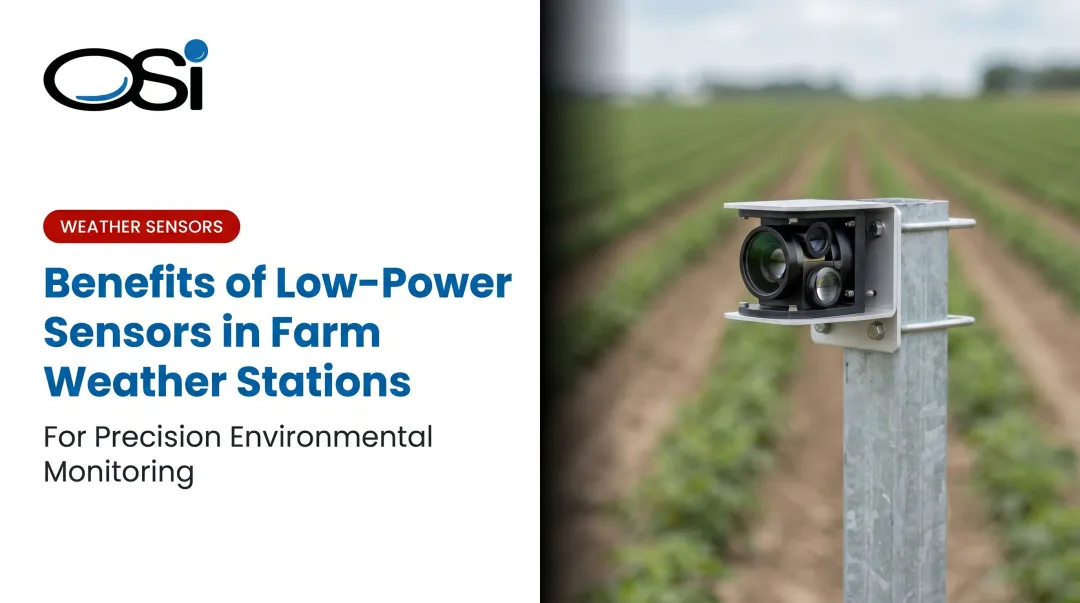
Introduction
Irrigation managers are under real pressure right now. As of May 2026, over 60% of the contiguous U.S. was in drought, while USDA data shows farms collectively spent $3.3 billion on pumping energy and $1.1 billion on purchased water in 2023 alone. Water costs are significant, regulations are tightening, and the margin for inefficiency keeps shrinking.
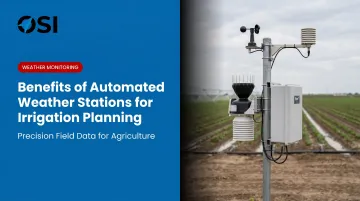
Automated weather stations (AWS) get framed as monitoring tools — useful for data collection, adequate for record-keeping. That framing undersells them. Their real leverage point is irrigation planning: when on-site atmospheric data feeds directly into scheduling decisions, managers consistently apply less water, spend less on pumping, and stay ahead of regulatory scrutiny.
This article covers three specific, measurable advantages AWS delivers for irrigation planning: how each one works, what it affects, and when it matters most.
Key Takeaways
- AWS captures hyperlocal conditions that regional forecasts miss, giving irrigators field-level data instead of approximations
- Evapotranspiration-based scheduling powered by AWS sensor inputs can cut irrigation water use by up to 50% without yield loss
- Real-time rainfall detection prevents irrigation from running when crops don't need it
- Multi-year AWS records sharpen seasonal water budgets and provide documentation for regulatory compliance
- Without on-site AWS data, irrigation defaults to fixed schedules that waste water, energy, and money
What Is an Automated Weather Station?
An automated weather station is a self-operating sensor system that continuously measures, records, and transmits atmospheric data without requiring manual observation. It runs around the clock and delivers consistent readings regardless of who is on-site. Parameters typically captured include:
An automated weather station is a self-operating sensor system that continuously measures, records, and transmits atmospheric data without manual observation. It runs around the clock, delivering consistent readings regardless of who is on-site. Parameters typically captured include:
- Temperature and relative humidity
- Precipitation type and accumulation
- Wind speed and direction
- Solar radiation
In agricultural contexts, AWS units are deployed directly in fields, at farm perimeters, across individual irrigation zones, or at water source locations. That placement matters. Regional weather services provide area-wide averages; an AWS captures what's actually happening at ground level in a specific field.
The distinction isn't trivial. A Central Valley study using 731 in-orchard weather stations found growing-degree-day discrepancies exceeding 300 GDD between localized in-orchard data and the nearest regional station. That gap translates to substantially different irrigation timing and water volumes in practice.
AWS is the data infrastructure that makes precision irrigation possible — feeding controllers, scheduling software, and every field management decision downstream.
Key Advantages of Automated Weather Stations for Irrigation Planning
The advantages below are operational and measurable. Each one connects directly to water usage, crop health, cost control, or labor efficiency. They also compound: AWS data used in isolation provides some benefit, but integrated with irrigation control systems, it produces the full return.
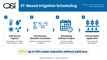
Advantage 1: Evapotranspiration-Based Irrigation Scheduling
AWS collects the inputs needed to calculate evapotranspiration (ET) — the combined rate at which water evaporates from soil and transpires through crops. That calculation answers the core question every irrigator faces daily: how much water do my crops actually need today?
Sensors measure temperature, humidity, solar radiation, and wind speed continuously. That data feeds into ET formulas — most commonly the FAO Penman-Monteith method, recognized by the FAO as the sole standard method for computing reference evapotranspiration — which irrigation scheduling software then converts into precise watering recommendations by crop type and growth stage.
ET-based scheduling replaces fixed-time or calendar-based irrigation, which applies the same water volume regardless of actual plant demand. That disconnect drives both overwatering and underwatering. Research cited by LSU AgCenter shows irrigation scheduling tools can reduce water use by up to 50% without reducing yields. A UF/IFAS study of a carambola orchard found ET-based controllers averaged 72% water savings compared to a standard timer schedule.
The cost consequences of getting this wrong run in both directions:
- Under-irrigation: Colorado State Extension data shows corn water deficit during the 12-leaf to dough stage can reduce yield by 11.5 bushels per acre-inch. USDA ARS research found deficit irrigation during grain filling can cut maize yield by 20% to 40%
- Over-irrigation: University of Nebraska Extension reports over-irrigating corn at 125% of actual crop water use reduced yields by up to 15 bushels per acre and causes nitrogen leaching, reduced oxygen in the root zone, and increased root disease risk
One important caveat: ET-based scheduling is only as accurate as the sensors feeding it. Imprecise or poorly maintained sensors produce flawed ET values that lead to incorrect irrigation decisions. OSI's precipitation and weather sensors are built on optical measurement technology with over 800 million field hours of operational data and an MTBF exceeding 80,000 hours, designed for exactly this kind of continuous, high-accuracy deployment where data integrity directly affects outcomes.
KPIs impacted:
- Water volume applied per acre-inch
- Irrigation energy cost
- Crop water-use efficiency
- Yield per unit of water
- Incidence of water-stress events
When it matters most: Peak growing season, drought-affected regions, and high-value crops where precise water management directly affects marketable yield.
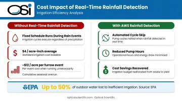
Advantage 2: Real-Time Rainfall Detection and Automated Irrigation Adjustment
AWS continuously monitors precipitation at the field level and either triggers direct irrigation shut-off signals or feeds real-time rainfall data to controllers, preventing irrigation from running during or immediately after natural rain events.
On-site rain gauges and present-weather sensors detect active rainfall and recent accumulation totals. That data transmits to irrigation controllers or farm management platforms that automatically skip scheduled cycles when soil moisture needs are already met by natural precipitation. OSI's APG-815-DS delivers full data updates every minute with instantaneous intensity readings every 10 seconds — fast enough for meaningful real-time response.
Regional weather forecasts regularly miss hyperlocal rain events. A field may receive measurable precipitation while the nearest weather station records none, or vice versa. Fixed schedules can't respond to that variability, resulting in habitual overwatering. EPA WaterSense estimates as much as 50% of outdoor water use is lost due to inefficient irrigation methods — a figure driven largely by systems that can't respond to actual conditions.
Every unnecessary irrigation cycle carries a direct cost. LSU AgCenter estimates average irrigation cost at approximately $4 per acre-inch; a single furrow-irrigation event averaging 3 acre-inches runs about $12 per acre. Across a full growing season with multiple unnecessary cycles, that compounds quickly — plus pump wear and labor time managing overruns.
KPIs impacted:
- Annual irrigation water consumption
- Pump operating hours
- Water/utility costs
- Number of irrigation cycles overridden per season
When it matters most: Variable spring and fall seasons with unpredictable rainfall, large-acreage operations where manual zone monitoring is impractical, and water-restricted areas where overuse carries regulatory penalties or tiered pricing consequences.
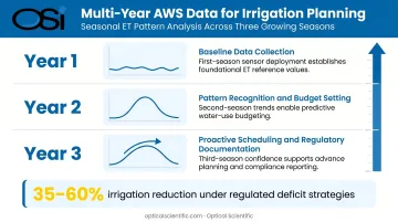
Advantage 3: Historical Weather Data for Seasonal and Crop-Specific Irrigation Planning
AWS systems log continuous weather records over time, creating a field-specific climate history. Planners use that record to design seasonal irrigation schedules, predict high-demand windows, and set baseline water budgets by crop type and growth stage.
Multi-year AWS data reveals reliable patterns: when peak ET months occur, how much supplemental irrigation was needed in a dry spring versus a wet one, and how specific fields differ from the regional average. That history lets irrigation managers set smarter defaults and build contingency plans into seasonal programming before the season starts.
UC ANR's work with California vineyards illustrates this directly. Using current and historical ET data under regulated deficit irrigation strategies, growers can reduce irrigation volume to 35% to 60% of full potential water use while maintaining fruit quality targets.
Without local historical data, irrigation planning defaults to regional averages that may be significantly off for any specific field. AWS-collected history provides the precision baseline needed to:
- Allocate water budgets accurately at the start of each season
- Justify water rights applications with documented field-level data
- Meet regulatory requirements for documented irrigation efficiency (California, Arizona, and Colorado all require annual water-use reporting from agricultural water users above defined thresholds)
Over multiple seasons, that same data supports annual water budget forecasting. Operations can plan input costs, negotiate water contracts, and avoid mid-season shortfalls or regulatory penalties with documented evidence behind every decision.
KPIs impacted:
- Seasonal water budget variance
- Year-over-year water use per acre
- Irrigation scheduling accuracy
- Compliance documentation completeness
This advantage carries the most weight for perennial crop operations — orchards and vineyards where multi-year climate patterns directly govern irrigation strategy — and for large commercial farms managing multiple crop types or operating in regulated water districts requiring annual efficiency reporting.
What Happens When AWS Data Is Missing or Ignored
Without on-site automated weather data, irrigation planning reverts to guesswork. Schedules built on regional forecasts, calendar defaults, or operator intuition produce inconsistent watering that swings between over- and under-application depending on conditions no one is directly measuring.
The cost compounds over time:
- Fixed schedules waste water during wet periods and underapply during heat spikes
- Over-irrigation drives nutrient leaching, crop stress, and infrastructure wear from unnecessary pump cycles
- These are reactive problems — difficult to diagnose without data, meaning they often go unaddressed for full seasons
Scale makes this worse. As farms expand in acreage or irrigation zones multiply, the absence of localized weather data makes delegation and automation progressively harder. Every zone requires manual checking rather than data-informed rules — and manual checking doesn't scale.
NC State Extension states that routine irrigation at regular intervals in humid regions almost always wastes water and energy — and that water-balance scheduling can save 15% to 35% of water normally pumped. For large operations, that range represents a measurable reduction in both pumping costs and water rights exposure.
How to Get the Most Value from an Automated Weather Station for Irrigation
AWS delivers its full value when data is integrated directly into the irrigation control system — not just logged for review, but actively feeding automated scheduling adjustments, zone overrides, and real-time alerts.
Key practices:
- Integrate data into the control loop. AWS data should drive automated decisions, not sit in a dashboard waiting for someone to check it manually.
- Review outcomes against field results. Crop health, soil moisture trends, and water meter readings should be checked against AWS-driven recommendations regularly to catch calibration drift before it causes costly mis-scheduling.
- Prioritize sensor reliability. AWS data is only as good as the sensors collecting it. Look for stations with self-diagnostic capabilities, no-maintenance designs, and the ability to withstand weather extremes.
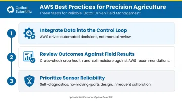
Sensor reliability is where hardware selection directly affects outcome quality. OSI's optical precipitation sensors are built around that third point specifically:
- Self-test and self-diagnostics run continuously, updating every minute and flagging potential issues in the output message
- Automatic Gain Control circuitry compensates for signal loss from dirty optics or LED output variation
- Field calibration is typically required only every two years
- No-moving-parts design eliminates mechanical wear entirely
These specs matter when sensors run unattended across a full growing season with no scheduled maintenance windows.
Conclusion
The core value of automated weather stations for irrigation is straightforward: decisions grounded in actual, real-time field conditions consistently outperform calendar-based or intuition-based schedules. That gap widens every season.
The three advantages covered here — ET-based precision, real-time rainfall response, and historical planning intelligence — build on each other over time. Each season of AWS data sharpens the next season's planning. Year one typically returns value through water savings; by year three, operators see tighter budgets, more accurate forecasts, and genuinely proactive scheduling instead of reactive fixes.
An AWS deployment is most accurately viewed as an ongoing data practice. The longer it stays integrated into irrigation decisions, the more precisely it fits your specific fields, crops, and climate patterns — and the harder it becomes to manage effectively without it.
Frequently Asked Questions
What are the advantages of automated weather stations?
Automated weather stations eliminate human error from data collection, run continuously without manual observation, and capture hyperlocal conditions that regional weather services miss. For irrigation scheduling, that on-site precision produces data that's actionable — not just approximate.
What are the advantages of automated irrigation systems?
Automated irrigation systems reduce labor, prevent overwatering and underwatering, and lower water and energy costs. Connected to on-site AWS data, their effectiveness increases substantially — preset schedules can't account for the variability that field sensors detect.
How do automated weather stations help reduce water waste in irrigation?
AWS sensors detect on-site rainfall and supply the temperature, humidity, solar radiation, and wind data needed to calculate evapotranspiration. Those inputs allow irrigation controllers to skip unnecessary cycles and apply only what crops actually need, cutting overuse at the source.
What weather data is most important for irrigation planning?
Temperature, relative humidity, solar radiation, wind speed, and precipitation are the critical inputs. Together, they're used to calculate evapotranspiration and determine actual crop water demand on a daily or even hourly basis.
Can an automated weather station operate in remote farm locations?
Yes. Modern AWS are designed for remote, unattended deployment — they operate on solar power, require minimal maintenance, and transmit data wirelessly via cellular, radio, or satellite. OSI's precipitation sensors, for example, run on 12 VDC and are solar-compatible, with MTBF exceeding 80,000 hours.
How does an automated weather station calculate evapotranspiration?
AWS sensors feed temperature, humidity, wind speed, and solar radiation data into ET formulas — most commonly the FAO Penman-Monteith equation — which produces a daily estimate of water lost from crops and soil. That figure forms the scientific basis for precise irrigation scheduling.