That number is RVR. It appears in METARs, on approach plates, and in ATC clearances constantly. But the system behind it — the sensors, physics, and data chain that produce those four-digit values — rarely gets explained in plain terms.
This guide covers how RVR actually works as a measurement system: the sensor technologies involved, how raw readings become reportable values, and how those values connect to the approach categories that govern low-visibility operations.
Key Takeaways
- RVR is the distance a pilot on the runway centerline can see runway markings or lights — derived from optical sensors, not human observers
- Two sensor types generate RVR: transmissometers (two-unit beam attenuation systems) and forward scatter sensors (single-unit scatterometers)
- Forward scatter systems have largely replaced transmissometers in the National Airspace System, per FAA Order 6560.10D
- Sensors at up to three points — touchdown, midpoint, and rollout — each report independent values
- RVR thresholds govern ILS approach categories (CAT I through CAT IIIb); both aircraft and ground equipment must be certified for each level
What Is Runway Visual Range (RVR)?
RVR is an instrumentally derived value — not an estimate. The FAA Pilot/Controller Glossary defines it as the range over which a pilot on the runway centerline can see surface markings or lights delineating the runway or identifying its centerline, based on standard calibrations.
Why RVR Exists Separately from Other Visibility Measures
Prevailing visibility — the number in statute miles on a METAR — represents the greatest horizontal distance visible across at least half the horizon circle. As a station-level observation, it tells you nothing specific about conditions at a point 1,000 feet past runway 28L's threshold.
RVR fills that gap. It's:
- Runway-specific — measured at defined points along a single runway
- Cockpit-calibrated — representing what a pilot would actually see from the centerline
- Sensor-derived — produced continuously by instrumented systems, not human observers
- Reported in feet (US) or meters internationally — not statute miles
What RVR Is Not
These three terms are related but govern different decisions:
- Prevailing visibility — station-level, reported in statute miles, used for general weather context
- Flight visibility — average forward horizontal distance a pilot sees from the cockpit in flight, required by 14 CFR 91.175 for descent below DA/DH
- RVR — runway-specific, sensor-derived, used in lieu of prevailing visibility when determining approach minimums for a particular runway
When RVR Is Reported
Those distinctions matter most when conditions deteriorate. In the US, RVR is reported in a METAR when prevailing visibility drops to 1 statute mile or less, or when RVR on an instrument runway has a reportable value (6,000 feet or less). Generating these readings requires FAA-certified transmissometers or forward scatter sensors positioned at specific runway locations — equipment not present at every airport.
How Does RVR Work?
RVR measurement follows a defined chain: sensors along the runway continuously sample atmospheric conditions, convert those readings into calibrated visibility values, and feed results to ATC systems and METAR reporting in near real time.
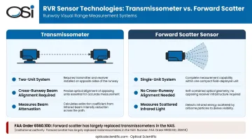
Sensor Technology: Transmissometers vs. Forward Scatter
Two fundamentally different optical approaches generate the raw data.
Transmissometers are two-unit systems. A light projector on one side of the runway transmits a beam to a receiver on the opposite side. The beam's attenuation (weakened by fog droplets, snow, or other particles) is measured as an extinction coefficient and converted to a visibility value. Precise cross-runway alignment is required, making transmissometers the legacy architecture in the NAS.
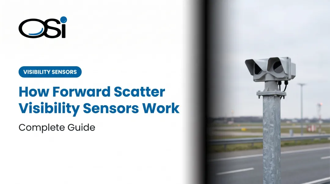
Forward scatter sensors (scatterometers) use a different approach. A single unit emits an infrared light source and measures the light scattered back from airborne particles at a defined angle. Because the projector and receiver are housed in one unit, they require no cross-runway alignment and are considerably easier to install and maintain.
Per FAA Order 6560.10D, scatter-effect systems have largely replaced transmissometers in the United States. Transmissometers are no longer installed except to replace existing units at runways served only by transmissometer systems.
OSI's OWI-430 DSP-WIVIS operates on this forward scatter principle, using off-axis scattering as its core visibility detection method. One receiver detects present weather through in-beam scintillation; a second measures meteorological optical range through forward scatter.
OSI's FAA-certified AWOS-AV system is built around this sensor platform and is designed for continuous aviation weather reporting with real-time ATC integration.
Sensor Placement Along the Runway
RVR systems use up to three sensor positions per runway, each reporting an independent value:
- Touchdown zone — positioned within 0–2,500 feet of the landing threshold
- Midpoint — located within 1,000 feet of the runway center point
- Rollout zone — positioned within 0–2,500 feet of the threshold at the far end
Each sensor captures localized atmospheric data. Because fog isn't uniform, the three values often differ significantly. A Volpe/FAA study of Chicago O'Hare found that during a January 1999 low-visibility event, one sensor reported CAT I or CAT II conditions while two adjacent sensors on the same runway showed CAT III. That's not a sensor error; it's an accurate picture of how patchy fog actually behaves.
Pilots and controllers must interpret the three RVR values holistically, not assume conditions are uniform across the full runway length.
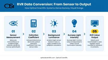
Data Processing and Reporting
Raw extinction or scatter readings don't become RVR values automatically. The conversion chain includes:
- The sensor measures the optical property (transmittance or scattered light intensity)
- Onboard electronics derive the extinction coefficient
- Background luminance — measured by an ambient light sensor — is factored in (runway lights are more visible at night than in daylight, affecting effective visual range)
- Runway light intensity is incorporated via a runway light monitor
- The result is converted to a discrete RVR value using Allard's Law and Koschmieder's Law calculations, then rounded to standard increments
Reporting increments per FAA JO 7900.5E:
| Range | Increment |
|---|---|
| Up to 1,000 ft | 100 ft |
| 1,000 to 3,000 ft | 200 ft |
| 3,000 to 6,000 ft | 500 ft |
METAR modifiers:
- M (minus) — value is below the lowest reportable threshold (for example, M0600 = less than 600 ft)
- P (plus) — value exceeds the highest reportable threshold (for example, P6000 = greater than 6,000 ft)
- V — separates two values when RVR fluctuates across more than one increment during the observation window (for example, 0700V1000 = varying between 700 and 1,000 ft)
RVR and ILS Approach Categories: The Operational Thresholds
RVR is the primary determinant for ILS approach categories — defining what visibility is required at the runway and in the cockpit for legal operations. Both ground equipment and aircraft avionics must be certified at the applicable level.
FAA-Defined ILS Minimums
| Category | Decision Height | RVR Minimum |
|---|---|---|
| CAT I | 200 ft | 2,400 ft (or 1,800 ft with TDZ/CL lighting) |
| CAT II | 100 ft | 1,200 ft |
| CAT IIIa | Below 100 ft or none | 700 ft |
| CAT IIIb | Below 50 ft or none | Less than 700 ft, not less than 150 ft |
| CAT IIIc | With or without DH | Less than 150 ft |
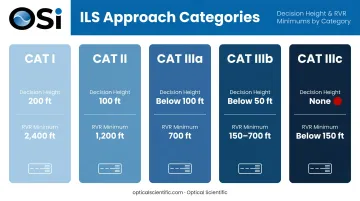
Source: AC 120-29A; FAA AIM Chapter 1
How ATC Uses RVR Operationally
Controllers use real-time RVR readings to:
- Set airport operating categories for active runways
- Issue approach clearances aligned with current category capability
- Protect ILS critical areas from ground vehicle interference during low-visibility operations
When RVR drops below published minimums, that doesn't automatically prohibit starting an approach under Part 91. It does signal that the required visual references — runway environment, approach lighting system — may not be achievable at decision altitude.
To legally descend below DA/DH and land, 14 CFR 91.175 requires three conditions simultaneously:
- The aircraft can land from its current position using normal maneuvers and a normal descent rate
- Flight visibility is not less than the prescribed minimum
- At least one required visual reference for the intended runway is distinctly visible and identifiable
RVR vs. Other Visibility Measures
The confusion between RVR, prevailing visibility, and related terms causes real operational errors. Here's how they actually differ.
Prevailing visibility is a horizon-level station observation, reported in statute miles, reflecting general airport-area conditions. RVR is runway-specific, expressed in feet, and calibrated to represent what a pilot physically sees from the centerline.
A METAR showing ½ SM prevailing visibility alongside an RVR of 2,400 feet is not contradictory. Each value reflects a different vantage point and a different operational question.
Runway Visibility Value (RVV) is an FAA ATC-recognized measurement from dedicated RVV equipment, reported when visibility is 1½ miles or less. Unlike RVR, it does not apply the same calibration adjustments for transmissometer placement and pilot eye-height corrections.
The table below shows how each measure applies across key operational decisions:
| Measure | Unit | Scope | Primary Use Case |
|---|---|---|---|
| Prevailing Visibility | Statute miles | Airport-wide | Takeoff minimums, general METAR reporting |
| RVR | Feet | Runway-specific | Approach minimums, low-visibility procedures |
| RVV | Miles | Runway-specific | ATC relay when RVR equipment is unavailable |
| Flight Visibility | Statute miles | Pilot-observed | Legal standard under 14 CFR 91.175 for descent below DA/DH |
Controllers relay RVR when available; prevailing visibility when RVR is unavailable. Selecting the wrong metric for a given decision — using prevailing visibility where RVR is required, for example — is a direct path to a regulatory or safety violation.
Conclusion
RVR is a calibrated, sensor-driven measurement system that translates atmospheric optical conditions at specific runway points into actionable visibility values — values that determine whether a runway is legally operational under a given approach category.
For aviation professionals managing airport weather infrastructure, the physics behind sensor type selection, placement tradeoffs, and multi-point data reliability limitations directly affect system performance during low-visibility approach operations. A forward scatter sensor that reads accurately in patchy radiation fog isn't just a technical specification — it's the difference between a usable CAT II runway and one that gets closed.
Optical Scientific's OWI series and FAA-certified AWOS-AV system are built on the same optical principles that underlie modern forward scatter RVR sensing. With MTBF exceeding 80,000 hours and no moving parts, they deliver the continuous, unattended operation airport visibility monitoring requires — with no scheduled optical maintenance between service intervals.
Frequently Asked Questions
What does runway visual range mean?
RVR is the distance a pilot positioned on the runway centerline can see runway surface markings or lights — expressed in feet (US) or meters internationally. It's derived from optical sensors installed along the runway, not estimated by human observers, and governs legal takeoff and landing conditions under low visibility.
What is the minimum runway visual range?
CAT IIIb operations allow RVR as low as 150 feet, while CAT IIIc (as defined in AC 120-29A) covers conditions below that threshold. Achieving these minimums requires both FAA-certified ground equipment and appropriately equipped, crew-qualified aircraft.
What is the difference between RVR, RVV, and prevailing visibility?
RVR is sensor-calibrated and represents the cockpit perspective on a specific runway. RVV is a direct instrument measurement recognized by FAA ATC, reported when 1½ miles or less. Prevailing visibility is a horizon-level station observation in statute miles. None of the three are interchangeable for approach minimums purposes.
How is RVR reported in a METAR?
RVR appears as R + runway number + / + four-digit value + FT — for example, R24/1800FT. The modifier M indicates below-minimum, P indicates above-maximum, and V separates two values when readings fluctuate (e.g., R24/0700V1000FT).
What weather conditions cause low RVR?
The FAA AIM identifies rain, snow, dust, fog, haze, and smoke as the primary obscuring conditions. RVR can also degrade unevenly along a runway's length, which is why certified systems use multiple sensor points rather than a single touchdown zone reading.
When is RVR reporting required at an airport?
In the US, RVR is reported when prevailing visibility drops to 1 statute mile or less, or when RVR on an instrument runway has a reportable value of 6,000 feet or less. RVR reporting is only available at airports equipped with certified RVR sensor systems — not all airports have this infrastructure.