Introduction
Wind speed measurement is not a passive exercise in data collection. An incorrect reading — or a reading taken from a poorly placed sensor — can ground aircraft that should fly, or worse, allow operations to continue when conditions are genuinely dangerous. The NTSB's investigation into a Salt Lake City aviation accident (AIR-25-05) identified an inadequate number of wind sensors and wind shear detection equipment as a contributing factor. The stakes are that concrete.
Getting measurement right starts with understanding the full picture. This guide covers:
- The instruments used to measure wind speed
- The three primary measurement methods
- How to interpret readings correctly
- The errors that consistently compromise data quality in real-world deployments
Key Takeaways
- Wind speed is measured using anemometers — cup, ultrasonic, and handheld vane types, each suited to different accuracy needs
- The WMO standard measurement height is 10 meters (33 feet) above open, level ground
- Sustained speed = 10-minute average; gusts = peak 3-second average — both are operationally distinct
- Sensor placement near obstructions is the most common source of systematic measurement error
- Critical infrastructure sites require fixed, professional-grade systems with continuous self-diagnostics
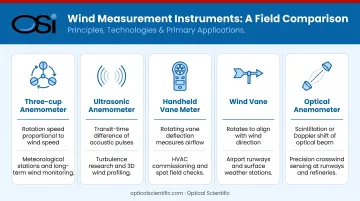
What You Need to Measure Wind Speed
Instrument selection starts with the application. A handheld meter works for a pesticide applicator checking field conditions before spraying. A fixed cup anemometer suits a standard meteorological station. For airports, refineries, or highway systems requiring uninterrupted 24/7 data, advanced optical or sonic sensors with no moving parts are the appropriate standard.
The table below maps each instrument type to its measurement principle and primary use case:
Core Instruments
| Instrument | Measurement Principle | Best For |
|---|---|---|
| Three-cup anemometer | Rotation rate proportional to wind speed | Weather stations, wind resource assessment |
| Ultrasonic (sonic) anemometer | Time-of-flight of sound pulses between transducers | High-accuracy, low-maintenance installations |
| Handheld vane/impeller anemometer | Portable impeller or vane rotation | Field spot checks, pre-flight assessment |
| Wind vane | Mechanical orientation to wind direction | Paired with anemometer for full wind data |
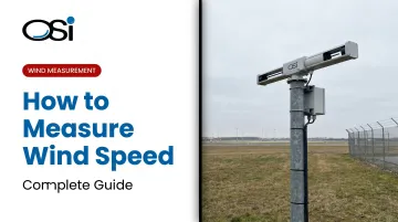
| Optical anemometer (such as the LOA series) | Optical scintillation — detects air parcel movement through an infrared beam | Long-baseline crosswind, wake vortex, fenceline monitoring |
Supporting Equipment
- Data logger or display unit for time-stamped recording
- Mounting mast or tripod rated for the wind loads expected at the site
- Compass for orienting wind vanes to true north
- Calibration reference documentation if regulatory compliance is required
Siting and Setup
Correct placement matters as much as instrument quality. WMO-No. 8 defines open terrain as any location where the distance between the anemometer and any obstruction is at least 10 times the height of that obstruction. A 5-meter tree requires 50 meters of clearance minimum.
Before recording begins:
- Confirm the anemometer is level and the mast is vertical
- Mount at 10 meters for standard meteorological use; aviation AWOS sites follow FAA-specific tower height requirements (typically 30–33 ft per AC 150/5220-16E)
- Orient wind vanes to true north using a compass
- Allow a stabilization period — typically 15–30 minutes — before logging data
Methods to Measure Wind Speed
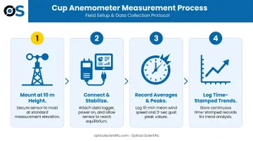
Method 1: Cup Anemometer
The three-cup anemometer is the most widely deployed instrument in meteorology and wind resource assessment. According to WMO-No. 8, rotor angular velocity in well-designed cup anemometers is directly proportional to wind speed — the rotation rate is converted to velocity through a calibration factor. It provides both average and instantaneous speed.
Step-by-step process:
- Mount at the required height (10 m standard) on a stable, vertical mast and orient the accompanying wind vane to true north
- Connect to a data logger, power on, and allow the system to stabilize before recording
- Record the 10-minute average for mean wind speed and the peak 3-second average for gusts, per WMO definitions
- Log time-stamped data for trend analysis — instantaneous snapshots alone are not operationally sufficient
Pros and cons:
- ✅ Low cost, widely understood, industry standard for wind resource surveys
- ✅ Pulse or frequency output integrates easily with most data loggers
- ❌ Moving parts wear over time and require regular inspection
- ❌ Susceptible to icing in cold climates — frozen cups produce zero output, not error flags
- ❌ Wind tunnel calibration is the only fully reliable calibration method (ISO 17713-1:2007 covers the test standard); field calibration alone is insufficient
Method 2: Ultrasonic (Sonic) Anemometer
Sonic anemometers measure wind speed by calculating the difference in travel time of ultrasonic pulses sent between transducer pairs in opposite directions. Faster wind shortens travel time in the downwind direction and extends it upwind. WMO-No. 8 confirms this time-of-flight principle and notes the absence of moving parts as a key durability advantage.
Step-by-step process:
- Mount at the required height, ensuring no obstructions block the transducer paths; orient per manufacturer specification (typically to true north or prevailing wind)
- Apply any wind tunnel calibration corrections specified by the manufacturer to account for flow distortion from the sensor housing
- Power on, confirm the system is logging at the required sampling frequency, and verify self-test indicators show no faults
Pros and cons:
- ✅ No moving parts — no bearings to wear, no mechanical failure in high wind events
- ✅ High-frequency output supports turbulence studies and gust analysis
- ✅ FAA Advisory Circular AC 150/5220-16E specifically added ultrasonic wind sensor criteria for AWOS, including a 1-knot wind speed threshold and direction accuracy within ±3 degrees RMSE
- ❌ Rain or ice on transducers can cause measurement inaccuracies — heated versions are available for cold-climate sites
- ❌ Higher upfront cost than cup anemometers
Sites where icing or point-measurement limitations make sonic sensors impractical have another option. Optical Scientific's (OSI) LOA series uses optical scintillation rather than sound to detect crosswinds and atmospheric turbulence across path lengths from 100 m to over 10 km. Tested and validated by NOAA and the EPA, it delivers path-averaged wind data suited to applications where a single point sensor cannot capture the full picture:
- Airport runway crosswind detection
- Refinery fenceline monitoring
- Wake vortex measurement
- Long-baseline atmospheric turbulence studies
Method 3: Handheld Wind Meter (Field Measurement)
A portable vane or impeller anemometer provides spot-check readings without fixed infrastructure. EPA pesticide drift guidance specifies that aerial applications require anemometer-verified wind speeds of 3–10 mph, and ground boom operations require 10 mph or less — both requiring an actual measurement, not an estimate.
Step-by-step process:
- Stand in an open area, clear of buildings and vehicles. Hold the instrument at arm's length at the intended measurement height — your own body creates a wind shadow that skews results
- Allow the reading to stabilize for 30–60 seconds and record the average, not the instantaneous peak
- Take multiple readings at intervals, then average them; note the height, location, and any nearby obstructions
Pros and cons:
- ✅ Highly portable and practical for construction sites, agriculture, and pre-flight checks
- ❌ Operator positioning introduces variability that is difficult to quantify
- ❌ Cannot log continuous data — unsuitable for compliance records or long-term meteorological analysis
How to Interpret Wind Speed Readings
A number in mph or m/s means little without context. The Beaufort Scale, operational thresholds, and the distinction between sustained speed and gusts all determine what response, if any, is appropriate.
Beaufort Scale Reference (Forces 0–12)
| Force | Term | mph | m/s | Operational Significance |
|---|---|---|---|---|
| 0–2 | Calm to Light breeze | 0–7 | 0–3 | Unrestricted outdoor operations |
| 3–4 | Gentle to Moderate breeze | 8–18 | 4–8 | Generally safe; light aircraft and spray operations normal |
| 5–6 | Fresh to Strong breeze | 19–31 | 9–14 | Caution zone for crane ops, spraying, light aircraft crosswinds |
| 7–9 | Near gale to Strong gale | 32–54 | 14–24 | Operational restrictions typical across most industries |
| 10–11 | Storm to Violent storm | 55–72 | 25–32 | Shutdown protocols required; structural risk |
| 12 | Hurricane force | 73+ | 32+ | Catastrophic; 73+ mph sustained (NWS Beaufort table) |
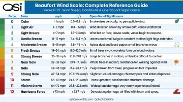
Sources: NWS Beaufort Scale, UK Met Office
Note on 70 mph: By the NWS Beaufort table, a sustained wind of 70 mph falls within Force 11 (Violent storm, 64–72 mph) — not Force 12. Hurricane classification (Force 12) begins at 73 mph sustained by the same table.
The Beaufort Scale describes conditions — industry standards define when those conditions require action.
Caution Thresholds by Industry
- Construction/personnel hoisting: OSHA 29 CFR 1926.1431 requires a qualified person safety determination when sustained winds or gusts exceed 20 mph at the personnel platform. The 2016 crane collapse at 40 Worth Street in New York involved recorded gusts of 30 mph, with estimated higher speeds at the 550-foot boom height.
- Pesticide application: EPA draft label guidance limits aerial application to 3–10 mph and ground boom to 10 mph or less, both verified by anemometer
- Aviation crosswinds: The FAA Airplane Flying Handbook requires pilots to compare actual conditions against the aircraft's demonstrated crosswind component — no single universal limit applies; thresholds vary by aircraft type
Units Conversion Reference
| From | To mph | To m/s | To km/h |
|---|---|---|---|
| 1 knot | 1.151 mph | 0.514 m/s | 1.852 km/h |
| 1 m/s | 2.237 mph | — | 3.6 km/h |
| 1 mph | 0.869 knots | 0.447 m/s | 1.609 km/h |
Source: NWS Wind Speed Unit Converter
Aviation uses knots, meteorology uses m/s, and transportation commonly uses mph. A METAR reporting 25 knots while ground crews expect mph means a 5 mph discrepancy in interpretation — enough to cross an operational threshold unnoticed.
Common Errors in Wind Speed Measurement
Most wind speed measurement failures trace back to procedural errors, not equipment failure.
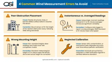
Poor placement near obstructions. WMO-No. 8 is explicit: any obstruction within a distance of less than 10 times its height will distort readings. A 3-meter fence 20 meters from the sensor violates this standard and will consistently underreport actual wind speed in that wind direction.
Confusing instantaneous and averaged readings. The WMO defines mean wind speed as the 10-minute average and gusts as the peak 3-second average. Reading only the live display value and recording it as mean wind speed is one of the most common field errors — it introduces large variability that makes trend analysis meaningless.
Wrong mounting height without correction. Wind speed increases with height. A reading taken at 2 meters will be substantially lower than the WMO standard 10-meter equivalent, following a logarithmic profile described in WMO-No. 8 — so any non-standard height requires correction before comparison with published data.
Neglecting calibration and inspection. Cup anemometers with worn bearings or damaged cups drift gradually, and the error is undetectable without a reference comparison. Per WMO-No. 8, fully reliable calibration requires a wind tunnel — field inspections catch physical damage but do not substitute for it.
Best Practices and Safety Considerations
Siting and mounting: Follow WMO standards — 10 m height, 10x obstruction clearance, true-north orientation for vanes. For continuous 24/7 operations at airports, highways, or industrial facilities, fixed systems with built-in self-diagnostics eliminate the gaps created by manual inspection schedules. For unattended deployments in extreme environments, instrument reliability becomes a critical selection criterion. OSI's FAA-certified AWOS-AV systems include continuous self-test and performance monitoring; the LOA series optical anemometers are rated from -50°C to 60°C with an MTBF exceeding 80,000 hours, which translates to years of uninterrupted operation through harsh winters without scheduled servicing.
Calibration schedule: Establish intervals based on instrument type and deployment intensity. General guidelines by instrument type:
- Cup and propeller anemometers: Wind tunnel calibration per ISO 17713-1:2007; WMO references a five-year interval for regional standards, though high-use sites may warrant shorter cycles
- Optical and sonic anemometers: Fewer mechanical failure modes with no moving parts, but data quality checks (comparing outputs against known references) should still follow a defined schedule
- All systems: Log every calibration event with date, result, and technician ID
This documentation trail is required for compliance audits and supports troubleshooting if data anomalies appear later.
Personal safety during field measurement: When measuring in adverse conditions:
- Wear secured headwear and non-slip footwear
- Maintain stable footing on level ground
- Never work near crane booms or elevated structures when winds exceed the equipment's operational limits
- Ensure all fixed sensor electrical connections are weather-sealed and grounded before energizing the system
Frequently Asked Questions
What is used to measure wind velocity?
Anemometers are the standard instruments. The most common types are cup anemometers (three rotating cups on a vertical shaft), ultrasonic anemometers (no moving parts, uses sound pulses between transducers), and handheld vane or impeller meters for portable field use.
How are 20-foot wind speeds measured?
The meteorological standard height is 10 meters (approximately 33 feet), not 20 feet. Readings at non-standard heights, such as 20 feet (~6 m), should be corrected using a wind profile model to estimate the equivalent 10 m value before comparing against published or regulatory data.
What is a 70 mph wind called?
By the Beaufort scale, 70 mph falls within Force 11 (Violent storm), covering 64–72 mph. Force 12 (hurricane force) begins at 73 mph sustained. NHC hurricane classification uses a separate 1-minute averaging standard with a 74 mph threshold, distinct from the Beaufort scale.
What is the difference between sustained wind speed and wind gusts?
Sustained wind speed is averaged over a 10-minute period (WMO standard) and represents general wind intensity. A gust is the peak 3-second average within that period, often substantially higher than the sustained reading, and matters for structural load calculations and operational decisions.
What is the standard height for measuring wind speed?
The WMO standard for open terrain meteorological measurement is 10 meters (33 feet) above ground level, chosen to minimize the influence of surface roughness and nearby obstructions.
How accurate are handheld anemometers compared to fixed weather stations?
Handheld meters are practical for spot checks but introduce variability from operator positioning and inconsistent measurement height. Fixed, properly sited stations with calibrated sensors provide continuous, standardized data required for aviation, regulatory, and research applications.