Introduction
Global food demand is projected to increase 60% by 2050, yet growing seasons are becoming less predictable and input costs continue to climb. For farmers managing that pressure, gut instinct and fixed schedules are no longer enough.
Agricultural sensors have become the practical answer. They form the data-collection layer of smart farming, converting real-world field conditions into signals that drive actual decisions.
The variables they capture range from soil moisture levels and rainfall intensity to nutrient concentrations and canopy health — each one feeding into choices like when to irrigate, when to spray, and where yields are underperforming.
This guide covers the main types of agricultural sensors in use today — what each one measures, where it performs best, and what farmers should weigh when choosing the right technology for their operation.
Key Takeaways
- Soil moisture sensors reduce irrigation water use by 27–45% without yield penalty, according to peer-reviewed research
- Electrochemical/nutrient sensors enable variable-rate fertilizer application — USDA data shows $17/acre profit gains and 14 lb/acre less nitrogen applied
- Weather and atmospheric sensors provide field-level data that regional forecasts miss, cutting fungicide applications by up to 62% in disease-forecast trials
- Optical sensors detect crop stress before visible symptoms appear — often days before the naked eye can
- Location and airflow sensors map soil compaction zones and guide precision equipment across variable terrain
- Sensor data only drives results when it's connected to a decision — matched to the right problem and fed into a management or automation system
What Are Agricultural Sensors?
Agricultural sensors are electronic devices programmed to detect and measure specific physical or chemical variables — moisture, temperature, nutrient concentration, light intensity, gas levels — and convert those measurements into electrical signals or digital data outputs.
In practice, they form the data collection backbone of smart farming systems. Most connect wirelessly — via WiFi, cellular, LoRaWAN, or NB-IoT — to farm management platforms or automated control systems, delivering continuous readings without requiring manual observation.
Deployment Models Vary Significantly
- Standalone probes — single-parameter units (such as a soil moisture rod at root depth) that report to a local controller
- Multi-sensor networks — distributed arrays across a field that feed into IoT platforms with analytics dashboards
- Mobile sensing — sensors mounted on equipment or drones that collect data across large areas in a single pass
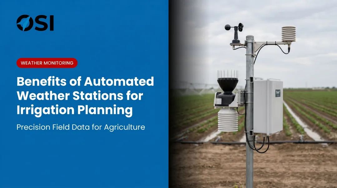
- Integrated weather stations — multi-parameter units measuring temperature, humidity, rainfall, wind, and solar radiation simultaneously
The right model depends on farm size, crop type, available connectivity, and what decisions the data needs to support.
Why Agricultural Sensors Matter for Modern Farming
Traditional farming decisions relied on seasonal schedules, manual field walks, and regional weather data. Those approaches held up when variability was predictable and inputs were cheap. Neither condition holds reliably today.
Sensors replace generalized assumptions with location-specific, real-time data. The productivity gains are well-documented:
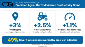
- USDA ERS research found GPS mapping raised corn-farm operating profit by nearly 3%, with guidance systems adding another 2.5% and variable-rate technology (VRT) contributing 1.1%
- Precision agriculture adopters worked 49% fewer hours per acre than non-adopters, per the same USDA analysis
- Crops use only about 50% of applied nitrogen on average — the rest is lost to the environment, creating both an economic and a regulatory problem that nutrient sensing directly addresses
The compliance case is equally compelling. Environmental regulators and agricultural policy programs are placing greater emphasis on nutrient runoff management, water use efficiency, and climate resilience. Sensor data — including precipitation and weather monitoring integrated into agrimet networks — provides both the operational means and the auditable documentation to meet those requirements.
Types of Agricultural Sensors
Not all agricultural sensors are interchangeable. Each type is built to measure different variables, operate in different conditions, and serve different decision-making purposes. Deploying the wrong type for the task produces poor data quality and wasted investment.
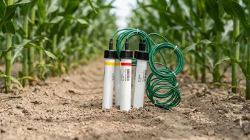
Soil Moisture Sensors
What they measure: Volumetric water content of soil. Most use dielectric technology (capacitive or TDR/FDR-based) — they detect changes in the dielectric permittivity of surrounding soil as moisture levels shift. Standard deployments place probes at 6, 12, and 24 inches depth to capture root-zone conditions.
Best suited for: Precision irrigation management in row crops, orchards, and greenhouses. Particularly valuable where water is scarce, expensive, or allocated under regulatory limits.
What the data shows: A 2020 Agricultural Water Management study found sensor-based irrigation scheduling delivered 27–45% less water than a soil-water-balance model approach, with no significant difference in crop growth or yield for pea and French bean.
Key strengths:
- Continuous root-zone water data without manual sampling
- Integrates directly with automated irrigation controllers
- Prevents both overwatering (root rot, nutrient leaching) and underwatering (stress, yield loss)
Limitations: Accuracy varies by soil type, salinity, and temperature. At electrical conductivity levels above 1.0 dS/m, several dielectric sensors show measurement distortion. Sensors buried in the field are also difficult to reposition if crop rotation or field conditions change.
Electrochemical and Soil Nutrient Sensors
What they measure: Specific ions and chemical compounds in soil: pH, electrical conductivity (EC), nitrogen, phosphorus, potassium (NPK), salinity, and heavy metals. These sensors convert chemical reactions into measurable electrical signals.
Best suited for: Operations focused on optimizing fertilizer application across a field, managing soil health over multiple seasons, or monitoring saline intrusion risk. Often mounted on sleds for mobile in-field mapping.
What the data shows: USDA ARS corn demonstrations reported $17/acre higher profit and 14 lb/acre less nitrogen from sensor-based nitrogen applications versus producer-chosen rates. In 55 Missouri on-farm sites, sensor-based nitrogen management increased partial profit by $42/ha and improved grain nitrogen efficiency from 67% to 73%.
Key strengths:
- Reveals nutrient variability across a field, enabling variable-rate fertilizer application
- pH data is critical for ensuring nutrients in soil are actually available for plant uptake
- Reduces chemical runoff and improves long-term soil health
Limitations: Require regular calibration and are sensitive to soil disturbance during sampling. Ion-selective electrode (ISE) systems for nitrate report accuracy of roughly ±16% in the 31–90 mg/L range and ±30% at lower concentrations. For precise measurements, lab confirmation of soil samples typically remains necessary.
Weather and Atmospheric Sensors
What they measure: The ambient environmental conditions that affect crop growth before stress shows up in plant physiology. This category includes:
- Temperature and humidity sensors
- Barometric pressure sensors
- Rain gauges (optical or tipping bucket)
- Anemometers (wind speed and direction)
- Solar radiation sensors
These are often packaged together in agricultural weather stations that monitor multiple parameters from a single installation.
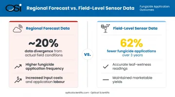
Why field-level data matters: Regional weather station data diverges from actual on-site conditions. In tomato disease forecasting trials, subscription weather estimates differed from on-site leaf-wetness data by about 20% on average — and frequently led to more fungicide applications than field-level data required. When using field-level sensor data, the TOM-CAST disease model reduced fungicide applications by 62% over three years while maintaining marketable yields.
Best suited for: Any operation where irrigation scheduling, spray timing, disease risk modeling, or harvest planning should respond to actual local conditions rather than regional forecasts. Particularly valuable in areas with microclimatic variability or unreliable rainfall patterns.
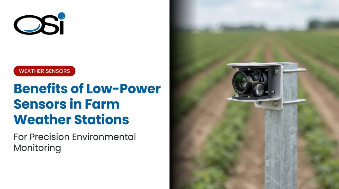
For AgriMet and HydroMet deployments requiring continuous, unattended operation, Optical Scientific's APG-815-DS All Precipitation Gauge is designed around no-moving-parts optical scintillation technology. It discriminates between rain, snow, freezing rain, and mixed precipitation, tolerates dust buildup without accuracy loss, runs on 12 VDC (solar-compatible), and carries an MTBF exceeding 80,000 hours — a meaningful spec for remote sites where maintenance visits are infrequent.
Limitations: Weather sensors must be positioned carefully. A poorly sited station can return data that doesn't represent the surrounding crop area accurately. Precipitation sensors in high-dust or high-pollen environments need periodic verification, though optical designs that compensate algorithmically for lens contamination reduce this burden considerably.
Optical Sensors
What they measure: Crop health and soil properties by analyzing how plant canopies and soil surfaces reflect and absorb specific wavelengths of light: visible, near-infrared (NIR), and multispectral bands. These sensors can be mounted on drones, satellites, tractors, or handheld devices.
Where it fits: Large-scale operations where field scouting is impractical. Common applications include early detection of nitrogen deficiency, water stress mapping, and identifying disease or pest pressure before visible symptoms develop.
What the data shows: Active canopy sensors reduced nitrogen applications by 38.7 ± 20.8 kg N/ha without yield penalty in 77% of dryland corn sites in Nebraska, while improving partial factor productivity of nitrogen. Adoption of aerial imagery remains limited — USDA ERS data shows just 7% of corn acres and 9.8% of soybean acres used aerial imagery, suggesting most operations haven't yet adopted it at scale.
Key strengths:
- Surveys large areas quickly without physical contact
- Detects stress earlier than visual inspection allows
- Can estimate soil organic matter, clay content, and moisture without physical probes
Limitations: Cloud cover is a real operational constraint. Research published in Remote Sensing of Environment found many regions had less than 50% of 8-day growing-season composites meeting a 70% clarity threshold, particularly early-to-mid season. Aerial systems also add data processing complexity and cost.
Location and Airflow Sensors
What they measure: Two different but complementary variables.
- GPS/GNSS location sensors track exact equipment positions and enable variable-rate input application by linking position data to agronomic prescriptions. High-precision RTK-GPS provides centimeter-level accuracy for automated guidance.
- Airflow sensors measure resistance to air injected into soil at a set depth and volume, providing a proxy for soil compaction and structure across a field.
Common applications: GPS sensors are core infrastructure for any operation using automated guidance, drone operations, or variable-rate application. Airflow sensors identify compaction zones that restrict root growth and drainage — information critical for tillage planning. Global assessments have estimated 10–20% long-term productivity loss from soil compaction and water erosion, with compaction accounting for roughly 43% of that impact in high-input systems.
Limitations: RTK-GPS systems require ground reference stations or correction signals, adding infrastructure cost. Airflow sensors require equipment passes across the field to generate coverage maps and are not suited to continuous in-season monitoring.
How to Choose the Right Agricultural Sensor for Your Farm
The most common mistake in sensor adoption is starting with the technology rather than the problem. A few structured questions prevent most poor investment decisions.
Start With the Agronomic Decision
Ask: What decision am I trying to improve? Irrigation timing? Fertilizer rate? Disease spray windows? Yield gap analysis? Each decision maps to a specific sensor type. Skipping this step leads to collecting data that doesn't change how the farm operates.
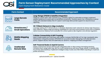
Match Sensor Type to Scale and Environment
| Farm Context | Recommended Approach |
|---|---|
| Large, remote fields | Long-range, low-power wireless (LoRaWAN, NB-IoT), extended battery life |
| Greenhouses / small operations | Higher-density, shorter-range networks with frequent transmission |
| Mobile mapping needs | Equipment-mounted sensors with GPS integration |
| Unattended remote sites | Solar-compatible sensors with built-in self-diagnostics |
Evaluate Integration Before Purchase
Sensors that don't communicate with your existing farm management software, irrigation controllers, or analytics platform create data silos rather than decision support. Prioritize sensors that:
- Output data via open protocols (RS-232, RS-485, Modbus, MQTT)
- Offer cloud-ready or IoT-gateway-compatible outputs
- Can be scaled without replacing core infrastructure
Factor In Total Cost of Ownership
Unit price is one input. Total cost of ownership tells the real story. Key drivers to evaluate:
- Calibration frequency: Electrochemical and optical sensors typically need recalibration more often than weather or soil moisture sensors
- Durability in field conditions — rain, dust, UV exposure, temperature swings, and physical disturbance add up. Verify IP ratings and published MTBF figures before committing
- A precision-agriculture wireless sensor network study reported data transmission success above 95% and packet loss below 2% in well-designed deployments; poorly designed networks fall well short of those numbers
- Sensors with built-in continuous self-diagnostics (such as OSI's APG-815-DS, which reports sensor health every minute) cut unplanned site visits significantly compared to sensors without remote status monitoring
What to Check Before Finalizing Your Agricultural Sensor Choice
Before committing to a sensor system, run through these common deployment pitfalls — each one can cost you accuracy, coverage, or budget after installation:
- Avoid over-specifying. A simpler, durable sensor that reliably answers your agronomic question outperforms a technically sophisticated one that generates data complexity without proportional benefit.
- Verify soil-specific accuracy. A moisture sensor that performs well in sandy loam may need recalibration in clay-heavy or saline soils — confirm specs against your actual field conditions, not just lab benchmarks.
- Confirm connectivity coverage first. Cellular and WiFi-dependent sensors can fail in remote or low-signal fields. LoRaWAN or satellite-connected sensors add upfront gateway costs but deliver reliable coverage where other protocols fall short.
- Match IP ratings to real field conditions. For unattended outdoor deployment, confirm the IP rating and operating temperature range against worst-case field exposure — not just average seasonal conditions.
Conclusion
Agricultural sensors covering soil moisture, weather monitoring, optical crop assessment, nutrient detection, and precision location have moved from supplementary tools to foundational infrastructure — central to how farms manage costs, yields, and environmental compliance at the same time.
No single sensor type covers every need. The right choice connects a specific agronomic decision to the right measurement capability, at the right scale, with deployment requirements that match how the operation actually runs. Get that fit right, and field data stops being a reporting exercise and starts driving decisions that matter.
Frequently Asked Questions
What are the different types of agricultural sensors?
The main categories are soil moisture sensors, electrochemical/nutrient sensors, weather and atmospheric sensors, optical sensors, and location/airflow sensors. Each measures different variables — from soil water content to precipitation type to crop canopy reflectance — and serves distinct decision-making purposes.
What are the two most relevant sensors directly used in agriculture?
Soil moisture sensors and weather/atmospheric sensors are the most universally applicable. Soil moisture directly drives irrigation decisions at the root zone, while weather sensors provide the environmental context — rainfall, temperature, humidity, wind — that affects nearly every other farming operation, from spray timing to disease risk.
What is the difference between soil moisture sensors and soil nutrient sensors?
Soil moisture sensors measure water content using dielectric properties of soil, while soil nutrient sensors (electrochemical) detect specific chemical ions to assess pH, nitrogen, phosphorus, potassium, and salinity. Both inform input decisions, but the variables they track — and the actions they trigger — are entirely distinct.
How do agricultural sensors communicate data to farm management systems?
Common protocols include RS-232, RS-485, Modbus RTU, WiFi, cellular/4G, LoRaWAN, NB-IoT, and Ethernet. Protocol choice depends on range requirements, data transmission frequency, power availability, and existing connectivity infrastructure at the field location.
How often do agricultural sensors need to be calibrated or maintained?
It varies by sensor type. Electrochemical nutrient sensors require more frequent calibration than weather or soil moisture sensors. Sensors with built-in self-diagnostics report performance status continuously, reducing manual calibration burden and allowing proactive maintenance scheduling.
Can agricultural sensors operate continuously in all weather conditions?
Sensors designed for outdoor agricultural use are rated for field conditions, but performance varies by technology. Optical sensors are affected by cloud cover; some precipitation sensors in dusty environments need periodic verification. Designs with algorithmic compensation for lens contamination handle dust and debris better than conventional alternatives. Always verify the IP rating and operating temperature range before deploying any sensor unattended.