Introduction
According to FAA data, structural in-flight icing has been identified as a cause or contributing factor in an average of 4 accidents and 5 fatalities per year between 2008 and 2021. Those numbers look manageable in isolation. A single encounter with freezing rain can destroy an aircraft in minutes.
On October 26, 2020, near Lubbock, Texas, a pilot flying a Cessna 210 reported freezing rain on approach. Airspeed decayed. Control was lost. The NTSB's final report (CEN21LA030) cited the pilot's decision to fly a non-ice-equipped aircraft into icing conditions as the probable cause — with freezing rain listed explicitly as both a decision factor and an equipment effect.
Freezing rain is in a different category than snow or freezing drizzle. It creates severe clear ice on every exposed surface simultaneously, often faster than any protection system can respond.
This guide covers what freezing rain does to aircraft, how to handle it in the air and on the ground, and how airports detect it in real time. It's written for pilots, dispatchers, and airport operations personnel.
Key Takeaways
- FZRA (freezing rain) generates supercooled large droplets that freeze on contact, creating clear ice that spreads beyond de-icing boot coverage
- No aircraft is certified for flight in severe icing — if you encounter freezing rain in flight, exit the conditions immediately
- Holdover times in freezing rain are far shorter than in snow; Type I fluid provides only 2–5 minutes of protection in light freezing rain
- Pre-flight briefings must include TAFs, METARs, SIGMETs, and PIREPs; any FZRA group in a TAF requires a contingency plan before departure
- Airport runway braking deteriorates rapidly during freezing rain, and de-icing fluid supplies can deplete quickly under sustained conditions
What Freezing Rain Does to Aircraft
How It Forms and Why It's Different
Freezing rain forms through a temperature inversion. Precipitation starts as snow aloft, melts while passing through a warm layer, then falls as liquid droplets into a shallow sub-freezing layer near the surface. Those droplets arrive at your aircraft still liquid — supercooled — and freeze on contact with any surface at or below 0°C.
What makes freezing rain uniquely dangerous is droplet size. FAA Advisory Circular 91-74B defines supercooled large drops (SLDs) as water droplets larger than 50 micrometers remaining liquid below 0°C. Freezing rain droplets exceed 500 micrometers.
Because of their mass, those droplets spread across a wide area of the wing after impact, freezing into clear (glaze) ice that extends well aft of the leading edge stagnation point — beyond where de-icing boots or heated leading edges protect.
Snow doesn't do this. Freezing drizzle droplets are smaller and spread less. Freezing rain hits every exposed surface: wings, stabilizers, propellers, antennas, pitot tubes. The ice that forms is hard, transparent, and extremely difficult to remove — and that's before you factor in what it does to flight performance.
Aerodynamic Consequences
Clear ice alters wing camber, increases weight, and disrupts airflow in ways that compound each other fast. According to NASA Glenn research, just 2 minutes of clear icing can double drag and reduce maximum lift by 25–30%. AC 91-74B goes further: large-horn ice accretions can increase drag by 200% or more and reduce maximum lift coefficient by 40–50%.
All four primary forces are affected at once:
- Lift decreases as the wing's profile is distorted
- Weight increases from accumulated ice mass
- Drag increases dramatically, reducing airspeed
- Thrust must compensate for all three simultaneously
Beyond the wings, propeller blades accumulate ice unevenly, causing vibration and asymmetric loading. Pitot tubes and static ports can ice over, producing false airspeed, altitude, and vertical speed readings. Windshields can become completely obscured. NTSB Safety Alert SA-097 notes that as little as 1/4 inch of leading-edge ice can increase stall speed by 25 to 40 knots.
Icing Intensity and What "Severe" Actually Means
AC 91-74B defines four icing intensity levels. Freezing rain does not automatically qualify as "severe" by the intensity definition alone — but it creates conditions where protection systems frequently cannot keep pace:
| Intensity | Accumulation Rate | Implication |
|---|---|---|
| Trace | < 1/4 inch/hour | Minor concern |
| Light | 1/4 to 1 inch/hour | Manageable with equipment |
| Moderate | 1 to 3 inches/hour | Equipment stressed |
| Severe | > 3 inches/hour or uncontrollable accumulation | Immediate exit required |
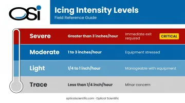
AC 91-74B is clear on one point most pilots underestimate: aircraft certified for flight in icing are not necessarily certified for freezing rain or freezing drizzle. Some aircraft are prohibited from these SLD conditions regardless of intensity. That distinction matters more than any accumulation rate measurement.
Aviation Safety Guidelines for Freezing Rain
Freezing rain safety is a continuous discipline — not a single action. It starts with weather analysis before departure, runs through ground de-icing procedures, and demands immediate response if conditions are encountered in flight.
Pre-Flight Safety Precautions
A thorough weather briefing is non-negotiable before any winter flight. Specifically:
- Review TAFs and METARs for FZRA at departure, en route, and destination
- Check SIGMETs for severe icing along the route
- Read PIREPs from aircraft that flew the route recently — terminal area reports below 3,000 feet are especially significant
- Understand TAF probability groups: TEMPO indicates a greater than 50% chance of a temporary condition; PROB30 indicates 30% probability. Neither means the event is safe to fly through if it occurs — it means your contingency plan needs to be ready before you start engines
Review atmospheric soundings or model data to understand the depth of the warm and cold layers. If freezing rain is forecast at the destination, your alternate must be far enough away to be genuinely clear — freezing rain bands can be widespread, and a nearby alternate may be in the same icing layer.
For GA VFR pilots: treat any TEMPO or PROB30 of FZRA as a likely cancellation trigger. Most GA aircraft lack ice protection certified for known icing, and even certified anti-icing systems can be overwhelmed rapidly by freezing rain.
Safety While Operating in Freezing Rain Conditions
If freezing rain is encountered in flight, exit immediately. Don't wait to assess severity — by the time accumulation is clearly visible, performance degradation is already underway.
Immediate response options:
- Turn back to non-icing conditions, the most reliable escape for most GA aircraft
- Climb above the warm layer, only realistic for jets with significant excess thrust; GA aircraft already accumulating ice may not have the climb performance left
- Descend to warmer air, only if terrain and ATC clearance permit
While executing the exit, maintain these priorities:
- Maintain airspeed above the elevated stall speed caused by ice accumulation
- Avoid steep turns
- Do not deploy flaps — AC 91-74B and AC 91-51A both warn that flap deflection in icing conditions can trigger tailplane stall
- Apply carburetor heat immediately on carbureted engines
- If the windshield ices over, open a side or storm window and fly to the runway without flaring on landing
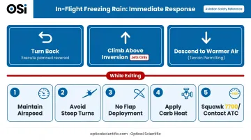
If conditions are deteriorating, squawk 7700 and contact ATC on 121.5 MHz. Priority handling reduces exposure time and gets you to a safe altitude faster.
On the ground, pilots must know their holdover time window. Return to the de-icing bay without hesitation if that window closes before takeoff clearance.
Environmental and Situational Awareness
Freezing rain most commonly forms ahead of warm fronts where cold air is trapped near the surface, and in valleys where cold air pools even after a front passes. A surface temperature increase or wind shift doesn't guarantee the icing layer has cleared.
Three observations that affect real-time decision-making:
- The transition zone between snow, freezing rain, and plain rain can be just a few kilometers wide — real-time surface observations from the destination are far more reliable than regional forecasts
- Severe icing PIREPs in the terminal area carry particular weight because aircraft on final approach pass through the freezing layer regardless of vectoring
- Runway condition reports (RSCs) from the destination provide direct evidence of surface conditions and should be part of any approach briefing during winter operations
How Airports Monitor and Detect Freezing Rain
Accurate, real-time present weather detection is the foundation of safe airport operations during freezing rain events. Without it, METARs lag behind actual conditions, holdover time calculations are based on guesswork, and pilots make go/no-go decisions on stale data.
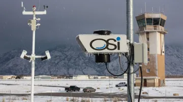
AWOS and Present Weather Sensing
FAA-certified Automated Weather Observing Systems (AWOS) provide continuous precipitation reporting — updating at least once per minute. The FAA's approved AWOS configurations include specific designations for freezing rain detection capability: AWOS III P adds present weather identification, and AWOS IV Z configurations specifically include freezing rain sensing.
Airports without reliable present weather sensing face a specific operational gap: the difference between FZRA and FZDZ or plain rain isn't always visible to the human eye, especially at night or in low visibility. Automated sensors that classify precipitation type continuously eliminate that ambiguity.
OSI's AWOS-AV and OWI Series
Optical Scientific, Inc. (OSI) acquired the Belfort FAA Certified AWOS-AV product line in 2017. The system is certified to FAR 91.171 and FAR 91.175 standards and is deployed at airports and aviation facilities across the US.
The present weather core of these systems is the OWI-430 DSP-WIVIS sensor, which meets the FAA AWOS present weather requirement and can discriminate between rain, snow, drizzle, freezing drizzle, and freezing rain — reporting over 60 NWS and WMO weather codes including FZRA and FZDZ. It uses three detection methods simultaneously:
- In-beam optical scintillation for precipitation type identification — distinguishing FZRA from FZDZ and plain rain in real time
- Off-axis forward scattering for visibility measurement across the sensor's full operating range
- Acoustic detection for hail and ice pellet discrimination, where optical methods alone can fall short
The system includes self-regulating dual lens heaters that prevent ice buildup on optical surfaces during freezing rain events — drawing more current as temperatures drop, without manual adjustment. With an MTBF exceeding 80,000 hours and built-in continuous self-diagnostics, these sensors keep reporting through sustained winter weather without requiring field intervention.
That continuous data stream feeds METAR reports and runway condition assessments in real time — giving de-icing crews and dispatchers the precipitation type inputs they need before holdover times run out.
Common Safety Mistakes to Avoid
Three errors come up repeatedly in freezing rain incidents and accidents:
1. Treating PROB30 or TEMPO FZRA as a low-risk forecast These codes reflect forecaster confidence in the event occurring, not the severity if it does. A 30% chance of freezing rain is still a 30% chance of one of aviation's most hazardous conditions. Have a contingency plan ready before you depart.
2. Assuming climb is always the right escape option For GA aircraft already accumulating ice, climbing may no longer be achievable. The additional weight and degraded aerodynamic performance reduce climb capability faster than most pilots anticipate. The exit decision must come early — well before significant accumulation. The Lubbock accident illustrates this: by the time the pilot was on approach in freezing rain in an unprotected aircraft, options were severely limited.
3. Departing without verifying holdover time hasn't expired FAA Holdover Time Guidelines for Winter 2025–2026 show the gap clearly:
| Fluid Type | Light Freezing Rain | Light Snow |
|---|---|---|
| Type I | 0:02 – 0:05 | 0:11 – 0:18 |
| Type IV (100/0) | 0:15 – 0:30 | 0:55 – 1:50 |
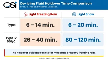
FAA tables provide no holdover time guidance for moderate or heavy freezing rain — conditions under which no anti-icing fluid can provide reliable protection.
Any delay between de-icing completion and takeoff roll — ATC sequencing, runway treatment pauses, congestion at the de-ice pad — may require a second treatment. Skipping the verification check has contributed to accidents.
Conclusion
Freezing rain is one of the most time-critical weather hazards in aviation because it acts on all surfaces simultaneously, generates ice that protection systems weren't designed to handle, and degrades performance before pilots have time to realize how serious the situation has become.
Managing that risk starts before the flight begins. Thorough pre-flight weather analysis, rigorous ground de-icing procedures, and immediate action when freezing rain is encountered in flight are the operational habits that keep pilots and passengers safe. Integrating freezing rain awareness into everyday winter operations — not just responding when conditions look bad — is what separates prepared crews from reactive ones.
At the airport level, that discipline depends on real-time weather data. Certified present weather sensors that continuously identify precipitation type — distinguishing FZRA from FZDZ or plain rain without human intervention — are what make accurate METARs, holdover time decisions, and runway condition reports possible when conditions are changing fast.
Frequently Asked Questions
Can airlines fly in freezing rain?
Airlines can operate in some freezing rain conditions, but operations are heavily constrained. Aircraft require de-icing with Type III or IV anti-icing fluid, holdover times drop sharply, and carriers may prohibit takeoff above certain intensities. Severe icing SIGMETs can restrict or halt operations entirely.
What does freezing rain indicate in aviation?
Freezing rain (METAR code FZRA) indicates a temperature inversion — warm air aloft has melted snow into rain droplets that are now supercooled at the surface. It signals severe icing conditions from the surface up to the base of the above-freezing layer and triggers mandatory de-icing requirements before any departure.
What is the METAR code for freezing rain, and how is it read?
FZRA is the standard METAR code for freezing rain. Light freezing rain appears as -FZRA, moderate as FZRA, and heavy as +FZRA.
Is freezing rain more dangerous than snow for aviation?
Yes. Freezing rain adheres instantly to all surfaces creating clear ice, is harder to remove than snow, reduces holdover times far more severely, and can form ice faster than de-icing equipment can manage. Runway conditions also deteriorate more rapidly under freezing rain than snow.
What type of ice does freezing rain cause on aircraft?
Freezing rain causes clear ice (also called glaze ice): heavy, transparent, and formed when supercooled droplets spread across the wing before freezing. It's the most hazardous type because it extends beyond de-icing boot coverage, disrupts airflow, and can increase drag by 200% or more.
What should a pilot do if they unexpectedly encounter freezing rain in flight?
Exit the icing conditions immediately: turn back, climb above the inversion if performance allows, or descend to warmer air if terrain permits. Maintain airspeed above the elevated stall speed, avoid steep turns and flap use, squawk 7700, and contact ATC for priority handling.