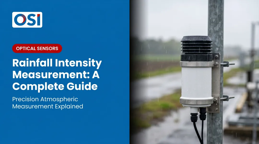
Introduction
Rainfall measurement sounds straightforward — until the data from two adjacent stations disagrees by 15%, or a tipping bucket gauge misses the peak intensity of a flash flood event entirely. For professionals in meteorology, hydrology, aviation, and transportation, those discrepancies aren't just inconvenient. They drive infrastructure decisions, flood warnings, and regulatory filings.
Rainfall measurement standards exist to prevent that kind of inconsistency. Defined primarily through WMO Publication No. 8 (Guide to Instruments and Methods of Observation), these internationally agreed guidelines cover:
- Units of measurement — which scales and resolutions are acceptable
- Gauge design requirements — which instrument types qualify for official use
- Siting criteria — how instruments must be positioned to minimize environmental error
- Data recording protocols — how observations are logged and transmitted
Without a shared framework, readings from different networks can't be meaningfully compared — and the decisions built on that data suffer for it.
This guide covers what those standards actually require, where WMO and NWS specifications diverge, and which instrument characteristics determine whether a gauge's rated accuracy holds up in real field conditions.
Key Takeaways
- Rainfall is measured in mm (accumulated depth) and mm/h (intensity) under WMO/SI standards; the U.S. uses inches operationally
- WMO specifies a minimum ~200 cm² collector opening; 0.2 mm resolution is standard, with 0.1 mm preferred for professional use
- Tipping bucket gauges are widely deployed but systematically underreport during heavy rain — this is documented in WMO literature
- Wind exposure, debris contamination, and siting geometry drive the most common real-world measurement errors
- Optical sensors with no moving parts avoid several of these error modes and work well in remote or high-stakes deployments
What Are Rainfall Measurement Standards and Why Do They Matter?
Rainfall measurement standards are internationally agreed rules that specify how precipitation should be observed, recorded, and reported. The primary document is WMO Publication No. 8, organized into five volumes covering meteorological variables, cryospheric variables, observing systems, space-based observations, and quality assurance. Chapter 6 of Volume I addresses precipitation measurement specifically.
Without common standards, data from one country's rain gauge network can't be meaningfully combined with data from another. That gap undermines flood forecasting models, water resource planning, climate research, and aviation safety systems — all of which depend on consistent precipitation data across borders.
How WMO and NWS Standards Differ
Operators sometimes assume WMO and U.S. National Weather Service standards are interchangeable. They aren't.
| Specification | WMO Guidance | U.S. NWS Standard |
|---|---|---|
| Minimum collector area | ~200 cm² | 8-inch gauge (~324.7 cm²) |
| Measurement resolution | 0.2 mm (0.1 mm preferred) | 0.01 inch (0.25 mm) |
| Unit system | Millimeters (mm) | Inches and hundredths |
The NWS 8-inch gauge exceeds the WMO minimum catchment area, but unit systems and resolution specifications still differ. The NWS 8-inch gauge exceeds the WMO minimum catchment area, but unit systems and resolution specifications still differ. A gauge procured to NWS specifications may satisfy some WMO requirements but not all — particularly for networks reporting into international WMO data exchanges.
Verify compliance against WMO No. 8 directly, not just the domestic standard.
WMO Standard Units, Gauge Sizes, and Resolutions for Rainfall
Units: Millimeters and mm/h
WMO specifies millimeters (mm) as the standard unit for accumulated precipitation depth. For intensity, WMO OSCAR lists precipitation intensity at surface in mm/h. The U.S. still reports operationally in inches and inches/hour, which creates friction when exchanging data with international networks. Conversion is straightforward mathematically, but the unit mismatch is a real source of error when automated systems ingest data from mixed networks.
Gauge Opening Size
Gauge physical design starts with collector area. A larger opening catches more drops per unit time, reducing the influence of random drop-size variability — an effect most pronounced during light rain events near a gauge's detection threshold.
- ~200 cm² (~16 cm diameter): Commonly cited WMO minimum for professional meteorological use
- ~324.7 cm² (8-inch diameter): U.S. NWS standard gauge
- Larger openings are preferable for high-resolution gauges; the statistical advantage is greatest for gauges measuring light rain events near their detection threshold
Resolution Tiers
WMO recognizes two main resolution tiers for synoptic-class observations:
- 0.2 mm: Established WMO standard for synoptic observation
- 0.1 mm: Increasingly required for professional and research applications
The NWS minimum is 0.01 inch (0.25 mm). Finer resolution improves light rain detection, but introduces its own vulnerabilities:
- Contamination and debris accumulation on collection surfaces
- Evaporation losses from the funnel between tip events
- Mechanical drift in tipping-bucket mechanisms over time
Coarser resolutions sidestep these failure modes but will miss trace events — a meaningful gap in hydrology and aviation weather applications where every millimeter counts.
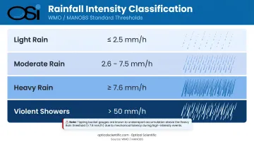
Rainfall Intensity Classification
Per Canada's MANOBS standards and WMO aviation guidance, intensity is categorized as:
| Intensity Category | Threshold | Notes |
|---|---|---|
| Light rain | ≤2.5 mm/h | — |
| Moderate rain | 2.6–7.5 mm/h | — |
| Heavy rain | ≥7.6 mm/h | — |
| Violent showers | >50 mm/h | WMO aviation classification |
Accurate intensity measurement requires both high resolution and a measurement mechanism that keeps pace with rapid accumulation. Most tipping bucket gauges begin undercounting above the heavy rain threshold — at accumulation rates above roughly 50–100 mm/h, tips occur faster than the mechanism can register, causing systematic data loss during the most operationally critical events.
How WMO-Compliant Rainfall Measurement Works
Under WMO No. 8, the standard measurement process follows a consistent chain: precipitation falls into a standardized collector (a funnel with a defined opening area), passes through a measurement mechanism, and is recorded at defined intervals. Each record must include metadata covering siting conditions, observation time, and instrument type.
Approved Instrument Types
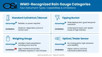
WMO recognizes four main gauge categories, each with distinct trade-offs:
1. Standard cylindrical (manual) gauges Accurate for accumulated totals and require no power, making them reliable where infrastructure is limited. The trade-off: accuracy depends entirely on observer procedure and timing, with no temporal resolution between readings.
2. Tipping bucket gauges The most widely deployed type worldwide, with self-recording capability and good temporal resolution. During intense rain, however, water enters the funnel faster than the bucket can tip — a portion is lost in the tipping motion itself. This produces systematic underreporting of both total depth and peak intensity during heavy events. WMO literature acknowledges this as an inherent mechanism error, not a manufacturing defect.
3. Weighing precipitation gauges Measure accumulated mass continuously, making them better suited for mixed precipitation (rain, snow, hail) since mass capture covers all forms equally. The trade-off is higher maintenance demand and susceptibility to wind-pressure errors on the load cell.
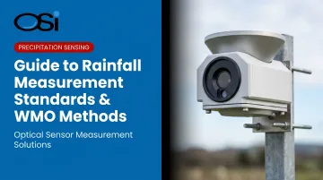
4. Optical and radar-based sensors No moving parts, capable of distinguishing precipitation type in real time, and not subject to the tipping-loss mechanism that causes intensity-dependent underreporting. OSI's APG-815-DS and OWI-430 series fall into this category, both deployed by NOAA and the NWS across the ASOS network and on ocean research buoys. The APG-815-DS uses optical scintillation rather than a collection orifice — measuring rain rates from 0.001 to 500+ mm/h at 0.001 mm resolution, which eliminates several error modes inherent to catch-type gauges.
WMO Siting Requirements
Instrument choice only matters if the gauge is correctly placed. Siting is where many otherwise-capable gauges fail in practice, and WMO guidance is specific about what's required:
- Gauges placed in open areas free from obstructions (buildings, trees, terrain features)
- No obstruction should subtend an angle greater than 45° from the gauge orifice — roughly meaning the gauge should be at least twice the height of any nearby obstruction away from it
- Poor siting is consistently identified in WMO literature as one of the leading sources of systematic measurement error across national networks
Observation and Reporting Intervals
Once siting is confirmed, reporting interval determines how useful the intensity data actually is:
- Synoptic stations typically observe every 1, 3, or 6 hours
- Automated stations can report at much shorter intervals for applications like flash flood monitoring and nowcasting
- A 0.2 mm resolution gauge reporting over 1 hour gives a very different intensity picture than the same gauge reporting over 10 minutes — the shorter interval exposes events the hourly average obscures
Key Factors That Affect Measurement Accuracy and WMO Compliance
Laboratory accuracy ratings don't translate directly to field performance. WMO Volume V on quality assurance treats field compatibility, intercomparison, and quality management as core requirements precisely because instrument specifications alone don't predict deployed accuracy.
Gauge Opening Size and Resolution
- Larger openings reduce statistical sampling error, especially for light rain and high-resolution gauges
- Finer resolutions (0.1 mm) detect trace events better but are more sensitive to debris and evaporation — a single leaf fragment represents a larger fraction of the measurement increment
- Match resolution and opening size to the application's actual accuracy requirements, not the finest specification available
Wind Exposure and Aerodynamic Catch Error
Wind is the most consistent and least-controlled error source in catch-type gauges. Air flowing over the gauge rim creates a turbulent updraft that deflects raindrops away from the orifice before they enter. This effect:
- Worsens with increasing wind speed and rain intensity
- Systematically undercounts precipitation — meaning the bias is directional, not random
- Applies to all catch-type gauges, including tipping buckets and weighing gauges
- Can be partially mitigated with wind shields and aerodynamic gauge designs, though not eliminated
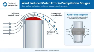
WMO acknowledges wind-induced catch error as a primary bias source, which makes siting to minimize exposure the first line of defense — before sensor selection even enters the picture.
Instrument Type and Sensor Technology
The choice of measurement mechanism introduces characteristic errors:
- Tipping buckets: Intensity-dependent underreporting during heavy rain; widespread deployment makes this a common data quality issue
- Weighing gauges: Better across intensity ranges but require regular servicing and are sensitive to debris on the load cell
- Optical sensors: Eliminate the tipping-loss mechanism; no moving parts means no mechanical drift or failure modes; self-diagnostics enable continuous health monitoring
In remote or safety-critical deployments such as highway RWIS stations, ocean buoys, and airport AWOS systems, sensor reliability matters as much as rated accuracy. OSI's optical precipitation sensors carry an MTBF exceeding 80,000 hours and require field calibration approximately every two years.
Built-in self-diagnostics update every minute and report error codes — including lens condition alerts — without requiring a site visit.
Maintenance Frequency and Debris Contamination
Insects, pollen, and leaf fragments accumulate in funnels and measurement mechanisms regardless of gauge design. High-resolution gauges are most vulnerable: at 0.1 mm resolution, a small debris fragment can register as a measurable event.
WMO guidance requires scheduled inspection and cleaning, but remote deployments frequently see extended maintenance gaps. Optical sensors with no collection funnel or tipping mechanism eliminate the debris-in-mechanism failure mode, though you'll still need to check lens surfaces periodically.
Common Issues and Misconceptions in Rainfall Measurement
Misconception 1: Datasheet accuracy equals field accuracy
Laboratory-rated accuracy reflects controlled conditions. In the field, wind-induced catch loss, funnel evaporation before tipping, debris interference, and improper siting all add error not captured in the specification sheet. WMO's quality management guidance treats field intercomparison, not specification review, as the proper basis for accuracy assessment.
Misconception 2: Rainfall amount and intensity are interchangeable
They measure different things:
- Amount (mm): Total depth accumulated over a defined period — answers "how much fell"
- Intensity (mm/h): Rate of accumulation — answers "how fast it fell"
Both matter for flash flood warnings, AWOS precipitation reporting, and stormwater design. Most tipping bucket gauges do not accurately resolve intensity at high rain rates because the tipping mechanism can't keep pace.
Using accumulated depth from a slow-response gauge to infer peak intensity underestimates flood risk.
Misconception 3: WMO and NWS standards are interchangeable
The two frameworks have different resolution thresholds, siting criteria, and reporting intervals — they are not drop-in substitutes for each other. Key distinctions to keep in mind:
- WMO No. 8 governs networks that feed into international data exchanges
- NWS specifications apply to domestic US observation networks
- Meeting one standard does not confirm compliance with the other
For networks with international reporting obligations, verify compliance against WMO No. 8 directly rather than inferring it from NWS conformance.
Frequently Asked Questions
What is the standard unit for measuring rainfall?
WMO recommends millimeters (mm) for accumulated precipitation and mm/h for intensity, consistent with SI units. The U.S. still uses inches and inches/hour operationally, which requires unit conversion when sharing data with international networks.
What are WMO rainfall measurement standards?
WMO standards are documented in Publication No. 8 (Guide to Instruments and Methods of Observation) and cover required units, approved gauge types, minimum catchment sizes, measurement resolution, siting rules, and data reporting requirements for internationally comparable precipitation data.
What is the minimum rain gauge size recommended by WMO?
~200 cm² (approximately 16 cm diameter) is the informal WMO minimum for professional meteorological use. The U.S. NWS standard 8-inch gauge covers approximately 324.7 cm², which exceeds this minimum but operates under a different unit system.
How does rain gauge resolution affect measurement accuracy?
Finer resolutions (0.1 mm) detect light rain better but are more susceptible to debris, evaporation, and mechanical drift. Coarser resolutions (0.2 mm) are more robust but may miss trace events. For context: achieving ≤2% resolution error with 0.2 mm resolution requires at least 10 mm of accumulation — calculated as resolution divided by target error percentage.
What causes tipping bucket rain gauges to underreport heavy rainfall?
During intense rain, water enters the funnel faster than the bucket tips. Rain accumulating mid-tip goes uncounted until the next cycle, after the peak has passed. WMO literature recognizes this as a design-inherent flaw that systematically underreports both total depth and peak intensity.
What is the difference between rainfall amount and rainfall intensity?
Rainfall amount is total water depth accumulated over a defined period (mm). Rainfall intensity is the rate of that accumulation (mm/h). Flash flood warnings, AWOS reports, and drainage design all require intensity, not just totals — which demands a gauge mechanism capable of resolving rapid changes in rain rate accurately.